Landscape / Farming
Changes in housing and population over the last 250 years
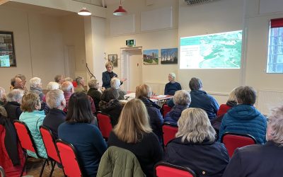
This Hadstock Society presentation was given by Richard Dolby on Wednesday 13th May, 2026. Chaired by Maggie Hartley, around 35 residents were in the village hall to hear how Hadstock housing evolved from the late 18th century through to 2026. Changes were explained using a series of map illustrations. The talk also featured lost cottages, shops and pubs, and the changes in population seen from census data over 250 years were summarised and discussed. Click on the picture above to see the illustrations and images used.
Hadstock Magazine extracts 1975-1985
Chosen by Rick Albrow, this is a selection of Hadstock Magazine articles to illustrate aspects of village life in the period 1975-1985. Our mounted scout troop, the village shop, and our victory in Uttlesford District’s ‘It’s a knock out’ competition, are among a dozen fascinating extracts.
Interactive map of the Hadstock Recreation Ground
http://[iframe%20width=768%20height=576%20src=https://maphub.net/embed_h/lkBBfbhgOhI5UI0p?panel=1&panel_closed=1%20frameborder=0%5DThis is a map of the Recreation Ground in 2024. Click on the icons to reveal photographs from several viewpoints and a general illustration of its main features.
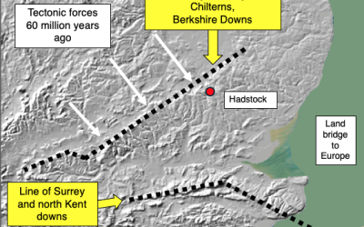
‘Landscape history of Hadstock Parish, Part 6: Geology, Terrain, Watersheds, and Soils’ by Richard Dolby
This presentation explains the geology of the Hadstock area, how the terrain was created, the watersheds that were formed and the soil types that developed.
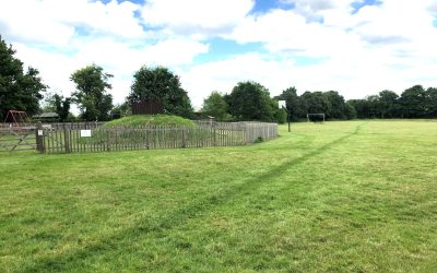
Hadstock Recreation Ground 2024
This is an interactive map showing the main habitats in the Recreation Ground in 2024
Hadstock Wood
This is a trial to establish how to embed maps with interactive buttons, showing text or images
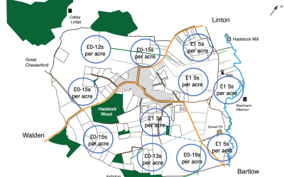
‘Landscape history of Hadstock Parish 1777-2020, Part 3: The 1801 Hadstock Inclosure Act’, by Richard Dolby and Rick Albrow
Part 3 of our Landscape History series illustrates and explains the Hadstock Inclosure Act of 1801. This transformed the landscape by affecting 70% of the Parish land area and eliminating open fields, shots and strips. New privately owned fields were created with the aim of improving productivity.
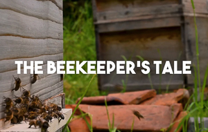
The Beekeeper’s Tale – by Tony Handley
Tony Handley explains the beekeeper’s art. “The Beekeeper’s Tale produced by Saul Woods and Licenced under CC-BY-NC: https://creativecommons.org/licenses/by-nc/4.0/ “
‘ Landscape history of Hadstock Parish 1777-2020, Part 5: Notable Buildings’, by Richard Dolby and Pat Croxton-Smith
This is a further addition to the series of illustrated online publications dealing with the landscape history of Hadstock Parish. Part 5 presents images and explanatory text on notable buildings, including St Botolph’s church, the former village school, listed houses, shops, large barns, pubs, mills and WW2 airfield structures.
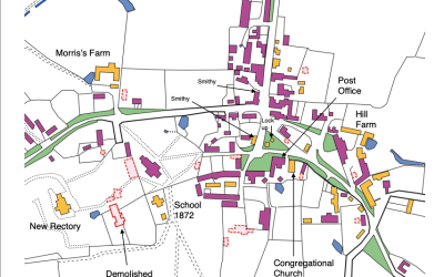
‘ Landscape history of Hadstock Parish 1777-2020, Part 4: Houses and the Built Environment’, by Richard Dolby and Pat Croxton-Smith
This is a new addition to the series of illustrated online publications on the history of Hadstock Parish. Part 4 focuses on the built environment, and beginning with buildings seen in the Chapman and André map of 1777, housing development in Hadstock and Bowsers over the last 240 years is presented and explained. The information was derived from seven published maps. ‘Lost ‘ buildings are highlighted and population changes explained.
‘ Landscape history of Hadstock Parish 1777-2020, Part 2: Field Systems. Fields and Ownership’ by Richard Dolby and Rick Albrow (pdf)
This is Part 2 of a series of illustrations and notes which looks at the landscape history of Hadstock Parish over the last 250 years. It examines the major changes in field systems, fields and ownership caused by the Hadstock Inclosure Act of 1801, the arrival of the railway in 1865 and the USAAF airfield in 1942. It concludes with the 2020 field landscape and field ownership.
Environment in Danger – a 1981 video portrait of Hadstock
In 1979, a BAA proposal to build a new terminal at Stansted Airport and expand passenger numbers to 15 million a year saw concerted action throughout Essex to oppose the planning application. A film, directed by Donald Stewart, was produced by the Hadstock Society which set out to show how the character and social life of those villages under the proposed flight path and stacking areas was potentially threatened.
The Society ran several events to finance the production, and various aerial shots were taken using a helicopter, courtesy of the Vesty family. The film was accepted and presented as evidence in the Public Inquiry which was held in Quendon in June 1982. The Inspector, Graham Eyre, commended the film and later it won the Essex Chronicle Award of the Essex Amenity Societies.
However, the Inquiry approved the BAA planning application in 1983 accepting a big increase in passenger numbers but turned down the need for a second runway. The new terminal was opened in 1991. Although the planning result was not the outcome wanted or expected in Hadstock, the film captures village life here 40 years ago in a charming and delightful way.
2021 AGM talk
This was a joint talk on ‘Fields and Field Systems of the Parish’ given by Rick Albrow and Richard Dolby after the AGM in November 2021
‘The Landscape History of Hadstock Parish 1777-2020, Part 2: Field Systems, Fields and Ownership’, by Richard Dolby and Rick Albrow (Flipbook)
This is Part 2 of a series of illustrations and notes which looks at the landscape history of Hadstock Parish over the last 250 years. It examines the major changes in field systems, fields and ownership caused by the Hadstock Inclosure Act of 1801, the arrival of the railway in 1865 and the USAAF airfield in 1942. It concludes with the 2020 field landscape and field ownership.
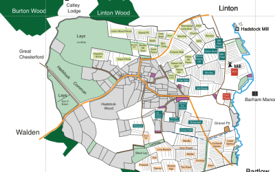
‘The Landscape History of Hadstock Parish, 1777-2020, Part 1: Boundaries, Roads, Woods, and Paths’ by Richard Dolby
Explore the changes in Parish landscape over the last 250 years. This is Part 1 of a series of illustrations and accompanying notes about Hadstock landscape history, and highlights the impact of the railways arriving in 1865 and the siting of the WW2 USAAF airfield in 1942.
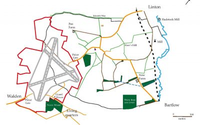
Aerial views of USAAF Station 165, 1944-1946
These images are courtesy of the American Air Museum in Britain, part of the Imperial War Museums, (www.americanairmuseum.com)
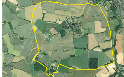
Parish Boundary Walk, May 2021
On Rogation Sunday, May 23rd 2021, and organised and led by Gill Butterworth, a group of Hadstock residents ‘beat the bounds’ and walked 7.5 miles round the Parish boundary as part of the 1020-2020 Millennium celebrations. Starting on Linton Road near the zoo, the group walked anticlockwise, had a lunch break in Nunn Wood, and finished in the Grip at Linton.
Memories of veterinary life in Hadstock by Crocky
Crocky worked with Dr Jock Dawson at the White House and recalls her work with dairy cows and other related happenings.
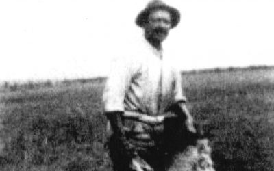
Marcus Barker, 1866-1944
Lived at Penn farm
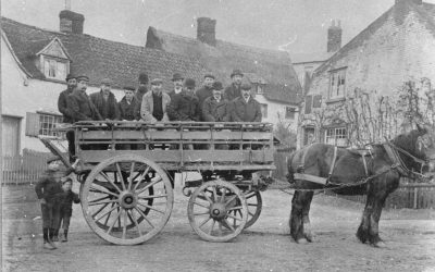
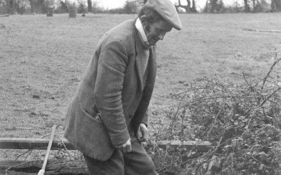
Farmworkers near Back Hill, 1920s
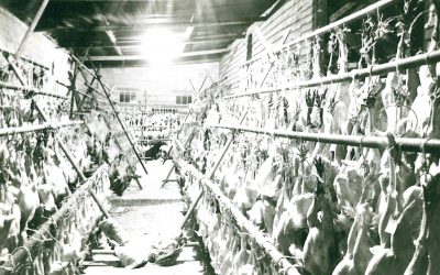
Crawley’s Christmas geese, 1950s
Denis and his ferret in Home paddock
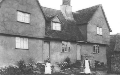
Hill Farm 1918 – built around 1480
